Showing posts with label Fairhaven. Show all posts

Tuesday, September 19, 2017

Pre-Jose Surf Check


With Hurricane Jose lurking offshore, we went to a few beaches to see what's what. We met the Weather Warrior up by Bert's in Plymouth.

Plymouth is a big town, so we also stopped at The Lobster Pound in Manomet.

Manomet needs a little off the top, so to speak.

The Tropical Storm Warnings are no longer applying to the South Shore.

"I am a rock, I am an iiiiiiisland."

I had to crawl down on the rocks to get better shots than the lazy NECN people in the van.


It looks very menacing if I zoom in, but this wave was about 18" high.

See?

Things will probably be a bit more perky tomorrow.


From Plymouth, we then headed to Duxbury. Duxbury was a bit far north for storm waves, but we may return there, so it's good to have some BEFORE pictures.


Duxbury Beach was fixin' to get angry, but it wasn't quite there yet.


Two of those equals Steve's house, no joke... that one has a better roof.

My camera levels well if I have a 1700 foot flat level thing to aim at... three or four times.

Whenever I look at this bridge- and  grew up in Duxbury- I always wonder what Evel Knevil would do with it. Eventually, you realize that nothing could top putting a ramp at the beach end and jumping the shark off of it. It worked for Fonzie, although the term lives in infamy.

There's no way Jose that a puny tropical storm was gonna keep ol' Poop Deck Pappy here from his appointed fish. I'm not picking on PDP, he's way cooler than I am and is most likely having a nice striper filet as we speak.

There would be a certain irony to being killed by a wind-blown lifeguard stand, sort of  the anti-Hasselhoff. Not a worry in Duxbury, though... they tip that ish over.

Best wave I saw in Duxbury, hoping Thursday will be better.

Why I never jog in the dark on Duxbury Beach... OK, that and 300000 Newports.


We actually started in Fairhaven, but we'll end up there now to give this article a snake-draft feel.

New moon high tide, should be fun tomorrow. We'll be out there somewhere...

Tuesday, July 11, 2017

Harboring: Fairhaven


We took the crew to Fairhaven to continue our Harboring series...


Nantucket Lightship? No thanks, already have one!


Both ends of the Intimidator


You probably don't want to steer your pleasure boat into the path of the Vanquish.


The Provincetown Fast Ferry, hanging around with some of the other working boats.

I don't know what that is, exactly... but somebody does, and that somebody thought enough of it to put it on a flatbed trailer until the need arose when it could be put to use.


The good ship Vantage, from motion to ocean...


Fairhaven, much more so than nearby Marion or Padanaram, is a working harbor. Even when I went there in April and May, it was a beehive of activity.


I tire of boats now and then, and revert to shooting at cool business signs.

I used to date a girl known as The Sea Witch before. She was from Green Harbor, but she may have opened a business in Fairhaven.

Don't be fooled by the sign... Fairhaven split from New Bedford in 1812.

"You know what the building needs? A giant mooring buoy! Yeah, right on the f***ing roof! The Missus will love it!" 

These ropes may have hauled up your dinner, Hoss. We'll give them a little respect, starting now.

I shot at this boat for 5 minutes before noticing a fisherman watching me. "Lawyer, tourist or magazine?" he yelled up to me. "The latter two," I replied. "Thought so," he laughed at me. "I see a photographer a day here."

The Karen Nicole and the Italian Princess, docked up all side by side.

She may be 19 and breathtaking, but something tells me that the eponymous Helen Irene may be older than that shack. Speaking of the shack, doesn't it look a bit like the one Captain Bob used to live in?

The Blue Sea, but not too deep.

Thanks for having us, Fairhaven!


Saturday, July 8, 2017

The New Bedford-Fairhaven Hurricane Barrier

Let's take a shot at describing the New Bedford/Fairhaven hurricane barrier.


The barrier was built between 1962 and 1966. It cost 18 million dollars and change. Estimates claim that it has already prevented 24 million in damages, so it's running in the black for an eternity now. Other estimates put the savings at around 60 million dollars.


New Bedford suffered mightily in the hurricanes of 1938, 1944 and 1954. The 1938 storm drove water 12.5 feet above the normal level. Much of New Bedford was under 8 feet of water. Two hurricanes hit in 1954, one producing a 11.9 foot surge that put New Betty under 6 feet of water... and then talk of building a wall started.


The barrier also protects less urban Fairhaven. In all, it protects 14,000 acres of New Bedford, Acushnet and Fairhaven.


The barrier protects 95,000 people in New Bedford, as well as New England's (and, accordingly, America's) most productive port. $368 million worth of seafood came in during 2011.


"I be up in them guts like every day..."


They block off the opening if the storm is bad enough.

Also safe behind the barrier is Palmer's Island Lighthouse, which goes back to New Beffuh's whaling era. That's the best pic I can do with a phone, and I tried a half dozen times.


You can only go so far out on the barrier before The Man puts the whammy on you.


A little zooming work as the boat toots through the barrier, above and below...
He was never seen again...


At the back right of the photo, you can see that the barrier has her own artillery brigade to make sure that the Other Man doesn't try anything sneaky. The English hold particular animus toward New Beige, and have taken several cracks at her over the years.

Here's the barrier hard at work protecting somebody's factory.


Four quick shots of the barrier where it would close off Rodney French Boulevard. I'm not 100% sure how it works, and hopefully I won't have to find out.


Guarding an apartment building and some triple deckers...


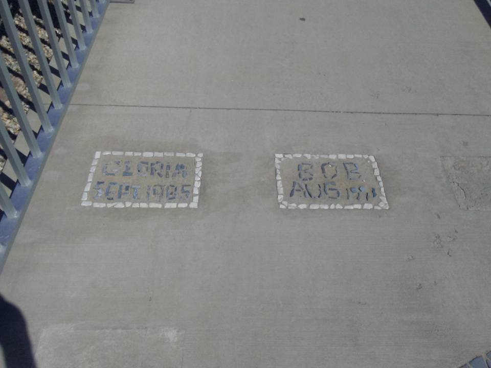
Hurricane history section, built into the walkway.

Gloria in 1985 and Bob in 1991 couldn't get past the wall. That empty third spot is miiiiighty ominous, however...


The hurricane barrier rocks.... noun or verb.


The "Irish Battleship" reference used in Boston to describe triple-deckers (built, as P.J. O'Rourke once noted, "before they figured out that you can't stack poor people who drink") may be "Portuguese Battleship" in New Bedford. Hopefully someone can enlighten us in the comments. These battleships, whoever lives in them, might actually put out to sea in bad storms if the barrier wasn't there.


Butler Flat Lighthouse, out of focus but on duty.

The gateway through the barrier as an incoming boat or storm might see it.

As you can see, property damage and loss of life would be tremendous if a hurricane hit before the barrier went up.


The Harborwalk, a 3400 foot walking trail atop the barrier, opened in 2015. It's my second favorite walk in New Bedford, just behind the walk from my car into Temptations Gentleman's Club.

One more shot of a boat approaching the barrier, you say? Just happen to have one right here...

Tremendous striper fishing grounds, although there are posted warnings about how many stripers you can eat a month from these waters. I saw an abandoned 40" fish on the Fairhaven side of the barrier that was just a little too gross to shoot a picture of.

If you stockpiled enough beer, tobacco and food... is there anywhere better in town to watch a hurricane roll in?


OK, maybe this guy's house...


What lays after the paved part of the Harborwalk ends...

Thanks for checking us out!


Front Door vs Back Door With Waterfront Houses

We are here today to discuss matters of great importance. Specifically... on a beach house or even a lake house, is the front door of...