 |
| God is chilin', Brant Rock, MA |
We hope you enjoyed last week's atmospheric entertainment, because we have another pile of powder pending.
An appetizer wil be served today, with the coast picking up 2" from a storm offshore. The storm could clip the Outer Cape harder, to the tune of 4" or so. It's snowing in Buzzards Bay as I start this (6 AM), so be prepared. It's just a preliminary to the main event, however.
The fun starts Sunday night, and should go straight through Monday. This won't be a blizzard to my knowledge, but more of a sustained snow event.
We'll get to all of that- and more- in a second, but let's scope some more damage first.
 |
| Duxbury Beach, MA |
We were taking the pictures during bright sunshine, so I apologize if some of the shots don't look gloomy enough.
Duxbury Beach, Brant Rock, Ocean Bluff and Green Harbor all took it on the chin during the Blizzard last week, especially Ocean Bluff and Brant Rock.
I'm lucky that I don't still live on Duxbury Beach, because I was heavily reliant on the Brant Rock Super Market for a lot of my food and tobacco. I'd need a boat and a deathwish to get there during the Blizz.
I did make it there during the Halloween Gale in 1991, but that was between tides and I had a Jeep.
Back to the snowstorm, yes....
 |
| Ocean Bluff, MA |
This will be a Groundhog, a rare weather-watcher term for a February 2nd snowfall. It's usually a terrible omen, worse than rai-ai-ain on your wedding day. I know a girl who got married during a tropical storm to some jerk, and it lasted maybe 6 months.
Groundhog Day, as you know, is when a rat in Pennsylvania crawls out of his little burrow. Depending on whether he sees his shadow or not, we get a longer winter or an early spring. It's an old tradition, brought to Pennsylvania by German immigrants.
If his shadow scares him and gives us 6 more weeks of deep winter, you can only imagine how he is going to react if he comes out and sees this particular stretch of weather we're having.
It will be a lot like how Hunter Thompson described Ross Perot... "He came out of his hidey-hole and saw that there were indeed many shadows about, and none of them were his."
Poof! Right back down the hole for six weeks. See you when the weather improves... in April.
 |
| Duxbury Beach, MA |
However, I do as well as the TV folks do, and beat them to the punch on the Blizz last week.
I do follow their forecasts, and they are on top of this storm we have coming Monday. We all seem to agree, although I'd argue (not too heartily, however) against a mix with rain on Cape Cod... something I, personally, was wrong about in the Blizz.
 |
| Ocean Bluff, MA |
WCVB has 6-12", with some mixing on the Cape. No one else has a mix presently forecast.
WHDH is going all-in with a 12-15" forecast for south of the Pike.
FOX gives us 9-13", with the worst in a Providence/New Bedford/Plymouth triangle.
NECN puts the 12" mark along a line from Duxbury to Providence.
Accuweather gives Bourne 7.9", Duxbury gets the same, Orleans gets 8.3", Bridgewater 7.7", and New Bedford gets 7.8". We'll get some more variety to those fiures as the storm nears.
There is some concern about coastal flooding. Winds aren't going to be insane, but there is a full moon high tide on Tuesday. It is an astronomically low full moon tide (Brant Rock has an 8.6 feet on Sunday night and 9.7 feet on Monday, as opposed to the 10.4 and 10.1 tides they had Monday and Tuesday, or the 11.5 they had a week before with the new moon), but the area is very vulnerable.
 |
| Brant Rock, MA |
It is a bad omen that the snow will start right about when a lot of bars are emptying after the Super Bowl.
The oncoming storm will blend nicely with the drunken revelers to produce what will be a distinct local disaster, Hurricane Brady.
It will be worse if the Pats lose, or even fail to cover. Drunks in a snowstorm are bad enough without factoring in potentially suicidal ones.
 |
| Ocean Bluff, MA |
Note that we have had very little melting between now and then, so this snow will fall on top of all of that lovely snow that you already have.
There is talk of more snow on Thursday, but we'll bury that bridge when we get to it.
That would make 4 storms in seven days, or 5 storms in 10 days (one of which was a monstahhh blizzard). That's straight-up Siberian, babe. Mother Nature shouldn't go and do me like that.
This is also happening during a frigid stretch. We'll have a low of 5 degrees in Buzzards Bay on Monday morning, and a high of 17 degrees on Tuesday.
 |
| Marshfield, MA |
I get a little confused as to just where the Marshfield villages of Ocean Bluff and Brant Rock begin and end. I should know this, I lived in the area forever and am somewhat of a historian/map person. Duxbury Beach and Green Harbor are divided by a clear town line, some socioeconomic factors, and a giant gap in their shared seawall.
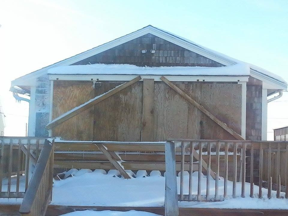
Ocean Bluff and Brant Rock aren't so easy, however. I use that Ice Church in the top photo as the cutoff point for the villages, with one wall facing the sea, one facing Ocean Bluff, one facing Brant Rock, and one facing Green Harbor in the distance. It's next to the Brant Rock Super Market, but on the bottom of the little hill that Ocean Bluff Package Store is on.
 |
| The newly-formed border village of Ocean Rock, MA! |
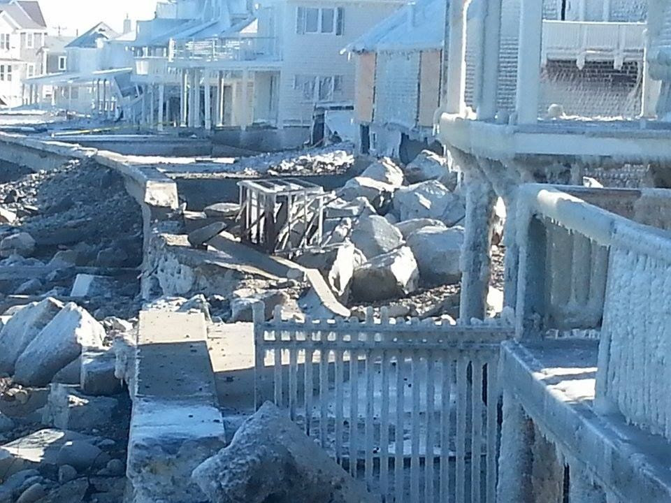
It's never a good sign for the houses when the tide breaks through a yard-thick seawall that has stood up to the Blizzard of '78, the Halloween Gale, and everything else since her 1950s birthdate.
I know that at least two houses were condemned, and several more may be on the chopping block from what I saw. Notice that the piles of stones against the surviving seawall give the ocean a nice ramp with which to tee off on these waterfront homes.
The boulders you see around it were partially put there to support the wall, but many others came to visit during the height of the Blizz.
You never realize just how many rocks are on the beach until the sea starts pouring them through a break in the seawall.
 |
| Brant Rock, MA |
Having lived next to the boat ramp opening in the Duxbury Beach seawall for 32 years, I can assure you that the ocean loves to pour itself through a breach. You get a funnel effect similar to what destroyed Bangladesh in that cyclone George Harrison did the concert about.
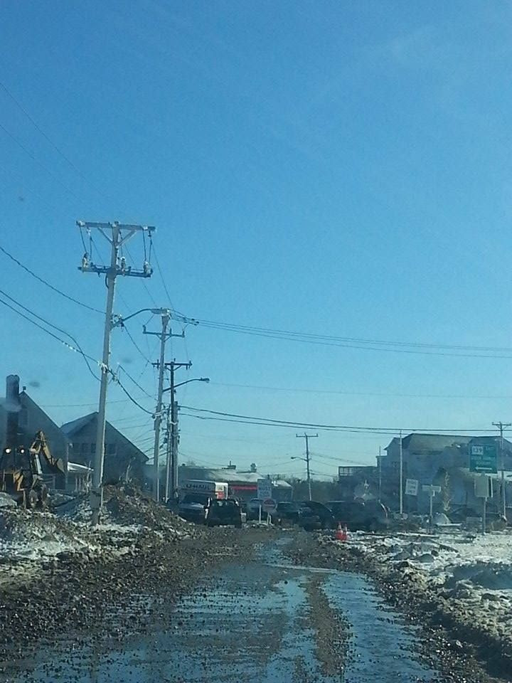
That's not some hick side street in the picture up above, that's Route 139 through Marshfield. The picture below is from my old house in Duxbury Beach.
 |
| Duxbury Beach, MA |
However, sand and stones shift with the tide, and much of Scituate is washing down and filling up the armored coastline of Marshachusetts. When you can step down to the beach from the top of the seawall like you can in Duxbury, you don't really have much protection left. A five-foot storm surge means that waves roll directly into houses. I've been in that, and it isn't fun.
The damage you see in these pictures are indeed direct wave action damage. At this point, we're not that far from a Sharknado scenario, where a Great White is washed ashore and eats someone coming out of the Venus II. It's not pretty, even when shot well.
 |
| Brant Rock, MA |
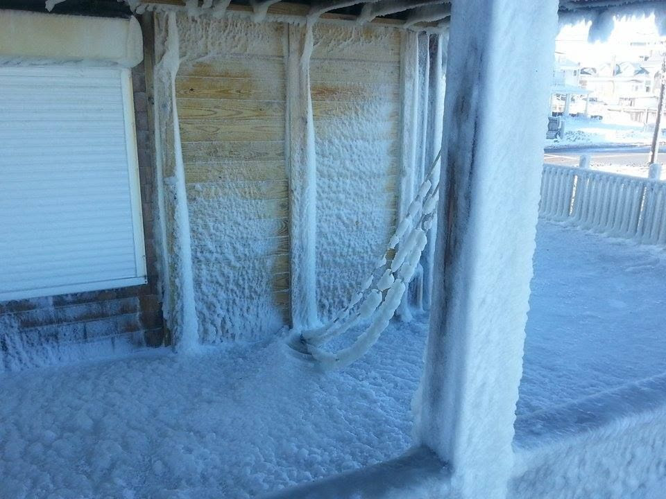
Yes, the ocean can freeze. After the Blizzard of '78, there were giant ice floe blocks extending down from the seawall to the low tide line on Duxbury Beach. This wasn't that bad, but that ice you see on the houses can collapse roofs, tear off gutters, break windows, or fall on your friggin' Marsh Vegas head.
It does look cool, though. I'd leave it up until the newsies stop coming 'round.
Note that the houses and the church with the ice coatings are across the street from the ocean, with a row of large houses in front of them. That's some ridiculous seaspray, player.
 |
| Ocean Bluff, MA |
 |
| Ocean Bluff, MA |
The picture below shows how they are patching the breach in the seawall.
 |
| Brant Rock, MA |
We did a whole huge ahhhticle about it back at the old paper, check it out, it will scare both you and your wallet.
Here's my old street in Duxbury Beach down below, taking shots but still looking good. The public stairs pictured there were my main hangout as a youth... right up until I was about 30, to be honest.
 |
| Duxbury Beach, MA |
Duxbury Beach is also, aside from Cable Hill, 100% at or below sea level. My cellar there was 3 feet below sea level.
Ocean Road North doesn't look that bad, until you realize that it isn't normally a dirt road. Duxbury Beach got off easy in this storm, hardly any damage at all. Brant Rock took the title with this storm.
 |
| Duxbury Beach, MA |
However, Cape Cod took their lumps with this storm.
Sandwich is a north-facing beach, and is normally protected by the Outer Cape. It also used to have a dune and replenishing sand-wash from the South Shore. Those things are gone now, and they are taking Scituate-style damage when a storm's wind turns North at the wrong time.
You can be hit by a wave while driving down Route 6A if you aren't careful, player.
 |
| Sandwich, MA |
If a Democrat in the Oval office isn't enough for you and you still want to see rich people suffer, you can enjoy a chuckle or two here. However, more of these houses are owned over several generations of blue-collar family history, and not everyone can just snap their fingers and make this all go away.
You can also get free lobster.
 |
| Duxbury Beach, MA |
It was a more common thing to see in the 1970s, before lobstermen (and women) switched from the wood pots to the wire ones. They, uhm, wash ashore less frequently for some reason, but no one is perfect.
The lobstermen got out on the beaches as soon as they were able to, to search for their gear. Every beach kid I knew was schooled to not touch the gear, but the lifted lobsters were the price for that respect. While I never poached one myself (I'm allergic), I can recall several lobsterfests after these Shady Harvests.
It may be an urban legend among beachfolk, but I think that lobstermen can shoot you if they catch you poaching their pots. I know a few, I'll ask them once I finish this and post it on the Facialbook.
 |
| Duxbury Beach, with the Gurnet in the background. |
It was not unusual for lobsters to wash ashore in storms before they were a) harvested commercially, and b) depleted massively. They were easy food for the Wampanoags and Pilgrims. It was go-to poor people food, Soul Food for the Pilgrim Poor.
Indentured servants in Plymouth during the Pilgrim times were fed lobster enough that they complained to at least one public official about it. Time, tide, water temperature, evolution and overfishing have pushed them deeper offshore in modern times.
The lobsters were pushed offshore, not the poor people. They get pushed inland, by storms and gentrification.
At least one live lobster came ashore sans lobster trap, although a resourceful seagull may have plucked him from a damaged trap. Either way, he didn't last long.
 |
| Duxbury Beach, MA |
Photos by Jessica, Stephen, Murph, Sara, Carter and Joe.
No comments:
Post a Comment